NEW TOWN FLOOD MAPS COULD IMPACT FUTURE CAPITAL AND DEVELOPMENT PROJECTS
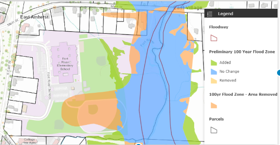
Revised flood map for area near Fort River School. During the previous school building project, the architects rejected this property as a potential school site based partly on the 1983 floodplain mapping, which indicated that a large area was designated as a 100-year floodplain. The revised, more precise maps showed that this area (in orange) was not part of the floodplain, making it available for building. Photo: http://amherstma.maps.arcgis.com/apps/webappviewer/index.html?id=e8cfe0b28b7c4bcd9b854484d6e7b631
By Maria Kopicki
New preliminary Flood Insurance Rate Maps (FIRM) were presented to the public at a joint meeting of the Amherst Planning Board and Conservation Commission on June 25, 2019. Approximately 20 residents attended the meeting at which Jeffrey Burm of AECOM company described the methods used to update the maps and the resulting maps, and Mike Warner, Amherst’s Applications Manager, explained how they affect Amherst.
The previous maps date back to 1983 and were developed using USGS (United States Geological Survey) topographic quadrangle maps with a scale of 1 inch per 2,000 feet and ten-foot elevation contours. Since then, a combination of new and improved topographic, hydrologic, and hydraulic data has produced maps with far greater precision and accuracy to conform with the Federal Emergency Management Agency (FEMA)’s current standards.
In 2009, a LiDAR (Light Detection and Ranging) survey was performed by Infotech Enterprises America, Inc. and the data were provided to AECOM for new maps. LiDAR is a surveying method that involves sending laser light from an airplane to the land below and measuring the distance that the light travels, in order to produce topographic information on a scale of 1 inch per 40 feet with 1-foot elevation contours, a significant improvement over the previous maps.
Then, in 2015, high-resolution aerial photography was undertaken by MassGIS (Massachusetts Geographic Information System Mapping Technology, Massachusetts Bureau of Geographic Information) and the results were added, showing detailed views of structures and land forms.
Hydrologic analyses were conducted on streams to estimate peak discharge/frequency and were used to estimate flood elevations. Detailed field methods were used on streams in “all known flood hazard areas and areas of projected development and proposed construction for the next five years,” according to the study, including portions of Mill River, Fort River, Plum Brook, Muddy Brook, Hop Brook, and Swamp Brook. Approximate methods were utilized on streams in “those areas having low development potential and minimal flood hazards,” including included Cushman Brook, Adams-Amethyst Brook, Lawrence Swamp, Hawley Brook, and the remaining portions of Plum Brook, Muddy Brook, and Hop Brook.
The above information was then compiled to delineate 100-year and 500-year floodplains and indicate their levels of flood risk. Here, FEMA defines a flood as “any relatively high streamflow overtopping the natural or artificial banks in any reach of a stream.” One-hundred-year floodplains have a 1 percent (1 in 100) annual chance of flooding and are referred to as “high risk areas,” while 500-year floodplains have a 0.2 percent (1 in 500) annual chance of flooding. The areas in between are considered moderate- to low-risk areas. These designations have implications for both flood insurance requirements and building restrictions.
As the current Flood Insurance Study explains, “Encroachment on flood plains, such as artificial fill, reduces the flood-carrying capacity, increases the flood heights of streams, and increases flood hazards in areas beyond the encroachment itself. One aspect of floodplain management involves balancing the economic gain from floodplain development against the resulting increase in flood hazard.”
The FIRM revision was first presented to Amherst residents in July 2016. Another study, conducted in 2017 by the USGS and Massachusetts DOT (Department of Transportation), used newer equations to estimate peak flows, and Town Meeting authorized funds for AECOM to apply its results to Fort River, Mill River, Muddy Brook, Plum Brook, Adams Brook, Amethyst Brook, Baby Carriage Brook, Cushman Brook, Hawley Brook, Hop Brook, and Montague Brook in Amherst. The company presented their findings in June.
What does this mean for potential capital and development projects, and for homeowners?
The interactive map available via the town website allows anyone to explore these maps and see how they have changed.

An example of how the revised maps can affect building planning is the Fort River Elementary School. During the previous school building project, the architects rejected this property as a potential school site based partly on the 1983 floodplain mapping, which indicated that a large area in the southern portion was designated as a 100-year floodplain. The revised maps, showed that this area (in orange) did not conform to the actual topography of the site and was therefore no longer part of the floodplain, making it available for building. The 2019 revision confirmed this finding and added a narrow strip of floodplain in the northeast corner around a streambed (in green).

Likewise, a large area (orange) between Meadow Street and Route 116 in North Amherst was also no longer categorized as a 100-year floodplain.

In contrast, the floodplain was expanded considerably north of this intersection, both west of Route 116 and near Sunderland Road in North Amherst,

and along the length of both Plum Brook and Muddy Brook in South Amherst (green).

After the maps were presented at the June 25 public meeting, a 90-day review and appeal period commenced. Anyone wishing to comment or request changes should address their concerns to AECOM (see below). Following resolution of any appeals, a letter of final determination will be sent to town officials, and the Town Council will vote on whether to adopt the changes. The Commonwealth and FEMA must also approve them in order for them to take effect about six months later.
Comments, questions, protests, and appeals should be sent to:
Jeffrey Burm, AECOM, One Federal Street, 8th Floor Boston, MA 02043 with copies to Kerry Bogdan, FEMA Region 1, 99 High Street, 6th Floor, Boston, MA 02110, Alex Sirotek, STARR, 99 High Street, 3rd Floor, Boston, MA 02110, Joy Duperault, Director, Flood Hazard Management Program, State NFIP Coordinator & Hazard Mitigation Officer,Dept. of Conservation & Recreation, Office of Water Resources, 251 Causeway Street, 8th floor, Boston, MA 02114