Zoning Primer: A Guide to Amherst’s 24 Zoning, Overlay, And “Other” Districts
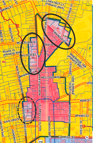
The current focus of many of the Planning Department is on proposed zoning changes in the BL District along North Pleasant Street and Triangle Street. Photo: amherstma.gov
Compiled from the Town website by Kitty Axelson-Berry
There are 11 categories of zoning districts in Amherst as well as 9 overlay districts and 4 “other” types of districts. Do you know what type of zoning district or overlay district you live in? What’s allowed there? Could your next-door neighbor sell their property to a developer who loves five-story apartment buildings? Could you build a small accessory dwelling in your backyard? How about a chicken coop?
B-G General Business
The purpose of the B-G District is to provide for a mixed-use area of high density, containing a wide variety of commercial, office, residential, institutional, civic, and cultural uses. To this end, it is intended that this district be applied within the town center of Amherst.
B-VC Village Center Business
The purpose of the B-VC District is to provide areas within the village centers of Amherst that allow for a mix of uses, including retail, commercial, offices, and housing of moderate to high density.
B-N Neighborhood Business
The purpose of the B-N District is to provide for areas of mixed use and moderate density to serve as small centers providing goods and services within or near residential neighborhoods, or as a transitional zone between more densely-developed business areas and residential neighborhoods.
B-L Limited Business
The purpose of the B-L District is to provide areas for moderate density, office, commercial, and multifamily developments. It is intended to be located in transitional areas between high-density business districts and high- density residential districts or in appropriate areas along arterial or primary roads.
COM Commercial
The purpose of the COM District is to provide areas for a wide range of retail uses and services and commercial activities in appropriate locations along primary roads within the Town.
R-G General Residence
The R-G District provides for medium and higher density neighborhoods (12,000 sq. ft. minimum lot area) near the town center. This area has historically had greater density and provides for residential use close to services and employment or educational opportunities in the town center or at the University.
R-N Neighborhood Residential
The R-N District provides for medium density residential areas (20,000 sq. ft. minimum lot area). This zoning designation is appropriate for neighborhoods adjacent to higher-density residential areas and near arterial or primary streets, or as transition to lower-density districts. This is the most common residential zone in Town.
R-O Outlying Residence
The R-O District provides for lower-density residential areas (30,000 sq. ft. minimum lot area). These areas are transitions between lower density R-LD District and medium density R-N District.
R-LD Low Density Residence
The R-LD District provides residential areas that allow limited development to protect environmentally sensitive areas, or agricultural or other natural resources. This is the lowest-density residential district (80,000 sq. ft. minimum lot area).
R-VC Village Center Residential
The R-VC District provides residential areas within and next to village centers. This district is medium density (15,000 sq. ft. minimum lot area) and allows a limited mix of residential and office uses.
R-F Fraternity Residence
The R-F Districts provide the only area for sorority, fraternity, and similar facilities associated with educational institutions.
And:
PRP Professional and Research Park
The purpose of the PRP District is to provide an open and attractive environment for office, research, and low-intensity industrial activities. The standards and regulations are intended to limit development to those activities that are non-commercial and that operate in a clean and quiet manner.
ED Educational
ED zoning allows any use of land and buildings which may legally be carried on by, or under the auspices of, the college or university which owns or manages the property. It is intended that the Educational District only include land which is owned or managed by Amherst College, Hampshire College, or the University of Massachusetts.
LI Light Industrial
The purpose of the LI District is to provide areas for certain light manufacturing, warehousing, wholesaling, and similar activities
OP Office Park
The purpose of the OP District is to provide areas for office and limited research activities. To this end, the standards and regulations are intended to limit the types of uses and to provide for a clean, open, and quiet environment that will not adversely impact adjoining residential areas.
And the Overlay Districts:
An overlay zoning district is placed “over” the underlying zone on the official zoning map as a way to adjust for special circumstances or changing situations such as agricultural protection or watershed protection. The overlay zoning district may or may not change the uses or the dimensional requirements allowed in that zoning district.
WP Watershed Protection
The WP District is an overlay district intended to provide additional protection to those lands which by virtue of their location, slope, and soils, make up the watersheds of the public water supply.
FPC Flood Prone Conservancy
FPC Districts consist of those geographical areas which by virtue of their relationship to components of the natural hydrology of the town have substantial importance to the protection of life and property against the hazards of floods, erosion, and pollution and in general are essential to the public health, safety, and welfare. To this end, the number and types of uses allowed are restricted.
ARP Aquifer Recharge Protections
The ARP District is intended to provide additional protection to those lands, which by virtue of their location, slope, soils, subsurface geology and water tables, constitute the recharge area for Zones I, II and III of the public water supply wells of the Town of Amherst within the Lawrence Swamp Aquifer.
FC Farmland Conservation
The FC District is configured to include, and intended to protect, those lands which, by virtue of their soils, acreage, location adjacent to and contiguous with other farm land, and lack of protection under existing underlying zoning, comprise the critical farmland of the town.
DR Design Review
The Design Review District is intended to include the General Business (B-G) District and the abutting Limited Business (B-L) districts. The purpose of the DR District is to support the success and vitality of Amherst’s town center by assuring that the historic character, aesthetic character, and functional quality of the design of town center buildings and sites are protected and enhanced. The DR District corresponds to those areas where the exterior design of new development or alterations requiring permits is subject to review by the Design Review Board.
TCDR Town Common Design Review District
TCDR District is an overlay district intended to include the Amherst town common and sites within 150 feet of the common greenspace, as measured from the outside edges of the curbs bordering the three sections of the common, parking lots and interior roadways inclusive. The purpose of the TCDR District is to protect and enhance the design of the historic common and that of the surrounding buildings and landscapes. The TCDR District corresponds to those areas where the exterior design of new development, or alteration on or within the vicinity of the common is subject to review by the Design Review Board.
PURD Planned Unit Residential Development
The purpose of the PURD District is to provide for a mixture of housing types and open space, with variations in dimensional requirements, in appropriate areas within the town, at greater densities than would otherwise be allowed by the underlying zoning. The requirements of this district are intended to encourage design of creative development, protection of the natural resources, and compatibility with surrounding areas.
MP Municipal Parking
The MP District is intended to include selected areas of the downtown General Business (B-G) District and abutting General Residence (R-G) District. Within the MP District, a wide range of permitted retail, service, commercial and residential uses shall be exempted from the requirement to provide off-street parking spaces. It is the policy of the town to encourage dense multi-use development in its town center. Toward that end, provision of off-street parking is not required for selected uses within the MP District.
R&D Research and Development
The R&D District is intended to modify the regulations in underlying business and industrial/research park districts in order to facilitate research and development and testing uses and to provide specific additional regulations with regard to such uses.
RESOURCES
For information about the district that you live in and what is allowed there, contact the Planning Department at 413-259-3040 or go to https://www.amherstma.gov/651/Planning-Zoning
For the Town Zoning District map go to https://www.amherstma.gov/1607/Amherst-Zoning-Map
For the Town Zoning Primer (the source of this article) go to https://www.amherstma.gov/DocumentCenter/View/24058/TMCC-Zoning-Primer?bidId= page 11 to 17
For the complete Zoning Bylaw go to https://www.amherstma.gov/476/Zoning-Bylaw
1 thought on “Zoning Primer: A Guide to Amherst’s 24 Zoning, Overlay, And “Other” Districts”