A Cold Day In Hell
My route in search of Mephistopheles. Image: Stephen Braun
At the risk of my mortal soul, I spent the Sabbath last week visiting four locations in our region associated with the Prince of Darkness: Devil’s Garden, Devil’s Football, Devil’s Den, and Devil’s Pulpit.
Like every state of the union, Massachusetts has numerous places named for the Devil or his abode. In fact, with 43 such locations, Massachusetts can claim to be the most devilish of the New England states (there are 29 such places in Connecticut, 23 in Maine, 9 in Vermont, 7 in New Hampshire, and only 3 in pious Rhode Island).
It says something—exactly what I’m not sure—that in practically any part of the country, the most interesting, beautiful, or unusual geological features are apt to be called Devil’s this or Satan’s that. The Devil has his own Golf Course (Death Valley), Bathtub (Rochester, NY), and Rocking Chair (Colorado), not to mention Dens across the country. As far as I can tell, God gets none of these fun, comfortable places. Nor any of the inspiring, majestic, or lovely places that also have been named for His alleged arch enemy, such as Devil’s Tower (Wyoming), Hell’s Canyon (Idaho), or Satan’s Kingdom (Connecticut).
This is not what I’d expect to find in a country colonized by Puritans and religious zealots of all sorts. But there you go. I’ve read that the “devil” moniker has been applied for various reasons. Sometimes it was because a place was sacred to the native inhabitants, which was threatening to the religious colonizers. Naming (or re-naming) a place or feature for the Devil was a way to demonize both the place and those who were attracted to it. Other times a place was labeled devilish because it looked weird, unusual, or creepy. And sometimes the word “Devil” or “Hell” was applied to a place for commercial purposes, the whiff of danger achieved thereby being much more likely to attract tourists than something bland like “Smith’s Rock.”
I’m fairly certain that the four places I visited all acquired their names simply because they just look kind of cool—although the coolness factor ranges significantly from a mild “huh, interesting,” to “Wow!” I started my trip at the hellish spot closest to my house.
Devil’s Garden
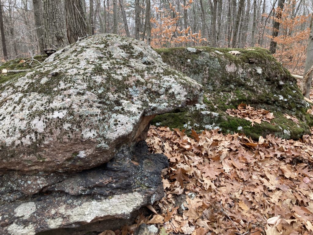
One of my maps of the Holyoke Range includes the label “Devil’s Garden” placed vaguely in the area just north of the Notch Visitor’s Center. I’ve always been curious about this, since, as far as I could tell, there was nothing there but forest. Online I found very little to enlighten me, aside from a mention that the Garden was a “boulder-strewn hillside” on the mountain road linking Amherst to South Hadley.
After some bushwhacking off of the Laurel Loop trail from the Visitor’s Center I found a collection of boulders in the woods that I can only assume is the supposedly devilish “garden.” Only one of these boulders was remotely interesting.
With some imagination you could see in this big rock some kind of animal with a gaping mouth. All the others were, well…just boulders. I suspect that these seemed more significant and interesting a century ago when the land was cleared for pastureland. Set in a wide expanse of close-cropped fields the boulders must have been noteworthy, although I’m hard-pressed to see how they would be worth labeling with such a portentous name. Bottom line: don’t bother with this one.
Devil’s Football
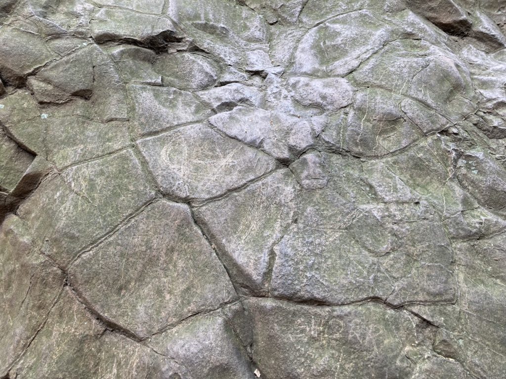
The “football” is probably the best-known of the devilish places on my trip—at least locally—because it’s easily accessed off of the well-traveled road up Mt. Holyoke and has signs pointing the way. It’s a conical hunk of basalt the size of a small house and estimated to weigh 300 tons. Basalt is very dense hardened lava, and this chunk fell from the high basalt cliffs that make up the Holyoke Range. I can only imagine the thunderous noise this thing must have made as it fell hundreds of feet, flattening trees as it went.
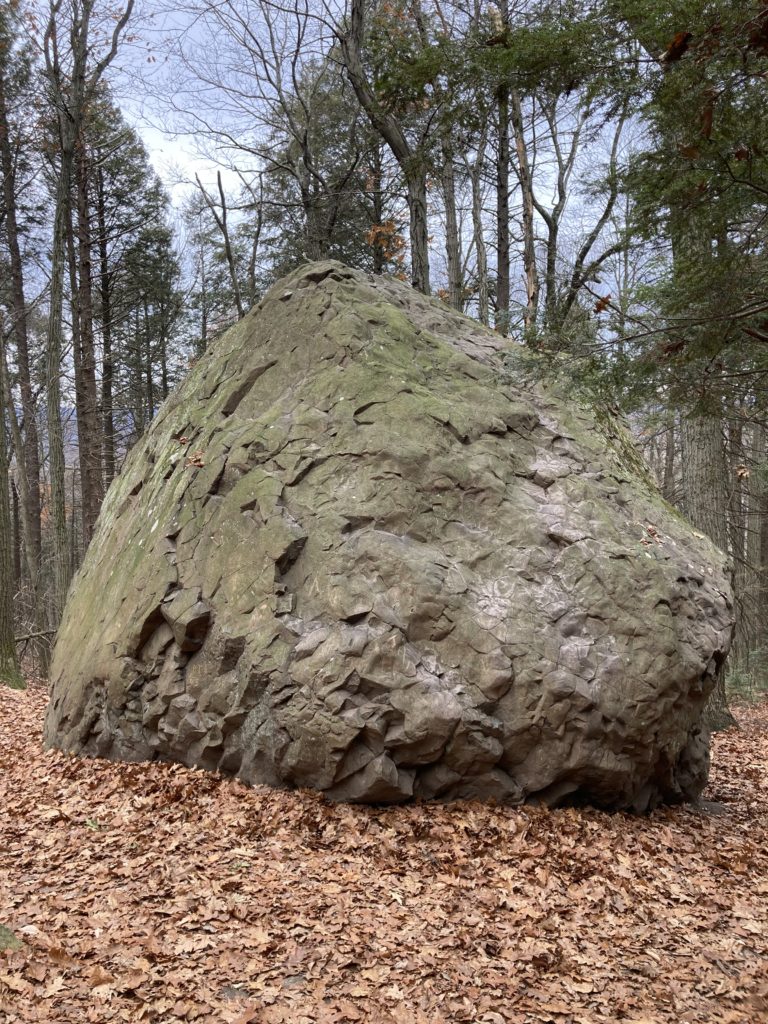
The “football” is made of a particularly iron-rich type of basalt. I’ve read that if you bring a compass near the rock the needle will deflect from true north because of the pull of all that iron. I haven’t tried this myself, but will the next time I’m up there. On one side of the “football” you can see polygonal lines that are a classic sign of basalt, created as the lava cooled, much as mud flats will crack when drying.
It’s possible to climb on top of the “football,” but it was chilly and I wanted to get to my next spot: Devil’s Den.
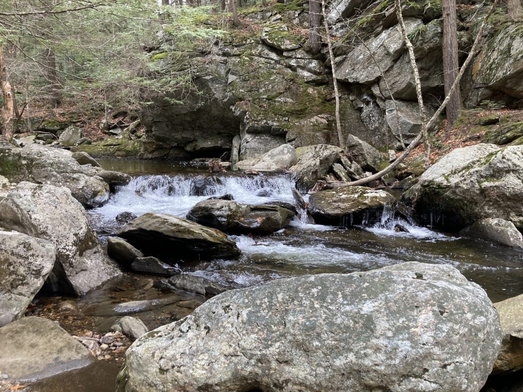
Devil’s Den
“Devil’s Den” is one of the most common of the many devilish place names, there being 10 of them in Massachusetts alone. This one, on the west branch of the Mill River near Goshen, is the closest such den to Amherst. It’s basically a cave-like overhang on a low cliff on the east side of the river adjacent to a lovely pool. The river, which is more like a stream at this point, reaches the Den by passing through a steep-walled valley choked with very large boulders, some of them displaying potholes of the kind I described recently. It can be a fun, if slippery, adventure to walk up the stream on a very hot summer’s day.
The Den is identified, vaguely, on Google Maps, but the trail to it is not labeled so it’s not easy to find, unless you’re shown the way by someone who’s been there. It’s also on private property, and signs prohibit camping or fires (but not walking or visiting). In any event, the Den is much more lovely and serene than scary or weird, so, again, I’m left wondering why anybody would have thought to name the place for the Antichrist.
Devil’s Pulpit
As I drove west from Devil’s Den and gained elevation it grew colder and snow appeared on the ground. At first just a dusting, it grew steadily deeper until by Pittsfield it was 5 inches deep and drifting. The snow was going to add a bit of a wrinkle to the hike required to see the last devilish place on my journey.
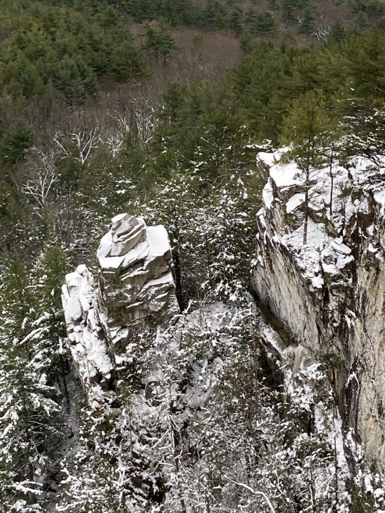
Monument Mountain is a 2.5-mile long, steep-sided ridge of quartzite—a hard, milky, kind of metamorphic rock—located just south of Stockbridge. The 1739-foot spine of rock lies within the Monument Mountain reservation managed by The Trustees of Reservations.
I took a looping trail heading steeply up the ridge, past boulders that seemed even larger than the Devil’s Football and a small cave rumored to be where Nathaniel Hawthorne and Herman Melville took shelter from a thunderstorm during a hike on August 5, 1850. While the friends waited out the storm, Hawthorne apparently gave Melville a pep talk, urging him to finish his book about hunting some strange whale. Melville did, of course, and he dedicated Moby Dick to Hawthorne.
It was icy on top of the ridge. The trail winds between huge exposed rocks to which short trees valiantly cling. After about a quarter-mile I came to the spur trail leading to a look-out spot from which one can view Devil’s Pulpit. A sign politely said “Enjoy the view—but be careful. Serious injuries and deaths have occurred here.”
The trail ended at some snow-covered rocks perched on the lip of a 600-foot cliff. I edged carefully to the precipice for a view. The fields and farms around Stockbridge spread out below me, framed by the Berkshires to the west and north. To the east was the Pulpit—a finger of rock about 75 feet high separated from the main cliff face and topped with a pedestal-like hunk of quartzite. It would, in fact, make a great pulpit for some being with a loud voice and an urgent message.
I wished I could get closer to the Pulpit. Scaling it would require a level of technical rock climbing skill I don’t possess, but maybe I could get to the base? I ruled it out after checking the map: it would require backtracking nearly to my starting point and then bushwhacking up again. I decided that was an adventure for another, warmer, day.
Monument Mountain is not wilderness by any stretch—the sound of traffic on Route 7 is always in the background. But I had the mountain to myself that day. The cold air smelled of snow and pine. A raven croaked grumpily in the distance. I did not succeed in spotting Beelzebub at any of His alleged locales. Quite the opposite. Each spot was special—holy, in a secular way. Sitting there quietly, above the Pulpit, I felt as close to heaven as I’m ever likely to be.
Almanac is a regular Indy column of observations, musings, and occasional harangues related to the woods, waters, mountains, and skies of the Pioneer Valley. Please feel free to comment on posts and add your own experiences or observations.
We really enjoy vicariously going on these nature treks with Steve. Looking forward to the next adventure!
Glad you enjoy the column Peggy! There’s a saying that goes something like: “A joy unshared dies young.” I sure enjoy my various rambles and adventures, but sharing them with readers like you adds a delightful dimension to those experiences and, truly, extends the joy. Thank you!