Hickory Ridge Trail System Planned for Spring

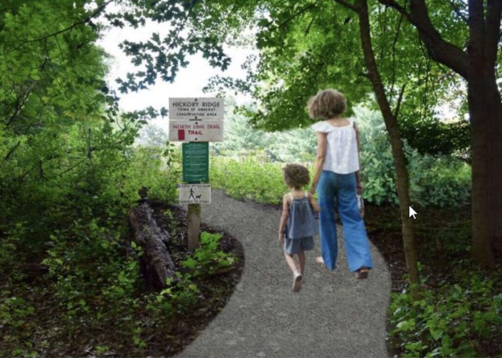
Artist's conception for accessible trail at Hickory Ridge. Photo: amherstma.gov
Report on the Meeting of the Amherst Planning Board, December 20, 2023
This meeting was held over Zoom and was recorded. It can be viewed here.
Present:
Doug Marshall (Chair), Bruce Coldham, Fred Hartwell, Jesse Mager, Janet McGowan, Johanna Neumann, and Karin Winter.
Staff: Chris Brestrup (Planning Director), Nate Malloy (Senior Planner), Dave Ziomek (Assistant Town Manager, Director of Conservation and Development), and Pam Field Sadler (Assistant).
Preliminary Trail Plans for Hickory Ridge Include Accessible Trail and Trail to Connect to East Hadley Road Apartment Complexes
Assistant Town Manager and Director of Conservation and Development Dave Ziomek explained that the town’s purchase of the 150 acre former Hickory Ridge golf course included plans for a 26-acre solar array currently being built by PureSky. The energy produced by this array will help power Springfield. Amherst obtained funding through a PARC (Parkland Acquisitions and Renovation for Communities) grant to develop an accessible loop trail on the property, and a Community Development Block Grant for a trail that connects the propertyto the apartment complexes to the north and to Pomeroy Center.
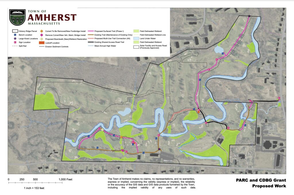
Ziomek said the siting of the trails was extremely challenging due to the abundant wetlands, vernal pools, and two miles of the Fort River, which is the longest free flowing tributary of the Connecticut River in Massachusetts. Part of the town’s goal is to restore the ecosystem and watercourse that was altered by the golf course by removing culverts and rewilding the vegetation. The area is also prime habitat for the woodland turtle.
In order to protect the turtle habitat and allow the river to return to its natural course, the town employed the Northampton landscape architecture firm Dodson and Flinker to help design the trail system. The town also consulted with the U.S. Fish and Wildlife Service and the National Heritage Foundation, as well as the town’s Conservation Commission, Design Review Board, and Disability Access Advisory Committee (DAAC).
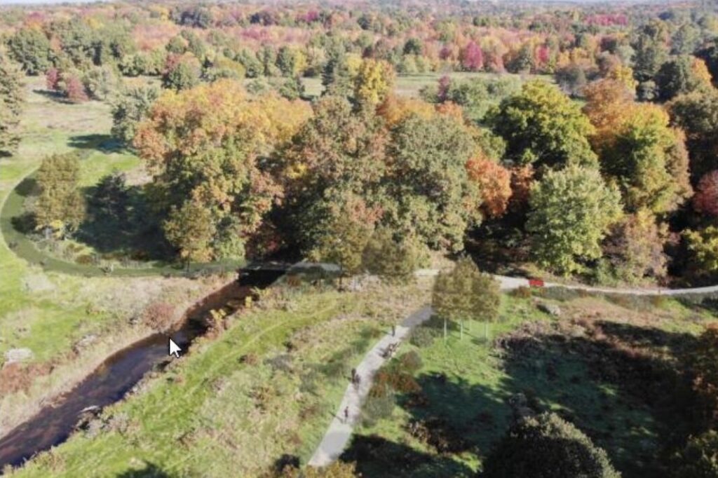
The accessible trail will be a six-foot wide loop track of crushed stone and bituminous material with two small bridges, a boardwalk, and a shaded area with benches. It will meet ADA standards, Ziomek said. It is expected that the trail will flood with heavy rains, but should recover with minimal maintenance. The loop will be located behind and to the west of the existing clubhouse, which is in poor condition and will eventually be torn down. There will be access to the accessible trail from the east side of the current parking lot. A new entrance to the 27-space lot will be constructed closer to Pomeroy Lane than the current entrance. There will be two handicapped spaces. For this early phase, the parking lot will be minimally upgraded, with only crack filling and relining.
The trail to the apartment complexes to the north will be mowed, but otherwise will have minimal change. There will be a shaded structure with benches near the southern end. There will be an exit onto West Street across from the Moan and Dove via the town-owned access for water and sewer vehicles. The closest PVTA stop is on West Street at that point. Ziomek said that he hopes to connect the northern trail to the accessible one when more funds are available. The Disability Access Advisory Committee asked about a sidewalk along West Pomeroy, but Ziomek said that would be prohibitively expensive at this time.
Because of time limitations on the grant, Ziomek hoped to put the plans out to bid in January, so that construction can begin in the spring. He said he hopes most of the work can be completed by June.
Questions and Concerns from the Planning Board
Planning Board member Janet McGowan asked whether there would be trash receptacles or dog waste containers at the site. At the site visit earlier that day, she noted several people walking their dogs and a used dog waste bag. Ziomek said that emptying trash receptacles, especially those with dog waste was very time consuming and unpleasant for the Conservation Department. He hoped that people would carry out all of their trash, but would reconsider if it became a problem. He said dogs are allowed on all 80 miles of Amherst’s conservation trails, but must be leashed, except for designated hours at Amethyst Brook and the Lower Mill River area. He pointed to the importance of protecting the Fort River from dog waste.
McGowan also wanted to be sure the town had enough staff to maintain the additional trails. Ziomek replied that no more staff would be hired to supplement the two-member Conservation Department, but he was amenable to having residents volunteer for trail maintenance. He added that these are the first new trails he has added to the town’s system since he became Director of Conservation and Development in 2005. Most trails were added during the 30 years that Pete Westover was Conservation Director. He also noted that the town has been cooperating with Kestrel Trust for trail maintenance.
Public Enthusiastic About the Plans
Several residents voiced their support for the trail plans. Claire Bertrand wanted to make sure a comprehensive ecological restoration plan was in place to protect the endangered mussels and wood turtles. Ziomek said that was the point of having the entire area surveyed by Dodson and Flinker to develop a master plan for development in the future. He said he was not sure how the five acres of developable land around the clubhouse would be used. It has been mentioned as the location of the South Amherst Fire Station or for senior housing. In any case, he said, the planned trails would not preclude those uses.
Ziomek said that several residents had contacted him about using the area for cross country skiing. He assured them that there would be a single-track ski trail system on the flatter section of the site, part of which would go all the way around the western solar array.
Karen Sanchez Eppler noted how close the trail from the north was to the solar array, and wanted to make sure there would be some plants to screen the solar panels. Benigno Sanchez asked if the trail would eventually connect to the Howard Garis trail that runs on the east side of the Fort River across from Crocker Farm School. Ziomek answered that the placement of the trail near the solar array was necessitated because of the sensitive ecological areas of the site. He said he hopes the trail system will eventually be able to connect to the Garis trail via a bridge across the river.
Marilyn Billings, who lives near East Hadley Road and frequently walks to the property, said she has never seen the trails to the north so flooded. Ziomek said he hopes the removal of the culverts and allowing the river to take its natural course will help control the flooding, but it is a very wet area. He said that there will be minimal improvement to the trail from East Hadley Road at this time. It will be mowed to discourage invasive species, poison ivy, and ticks, and he hopes mowing certain areas of the site will encourage a diverse ecosystem for grassland creatures and certain bird species.
Pam Rooney wondered about a trail to the northwest, but Ziomek said that was not in the current plans, and if it was created, it would probably not be accessible for strollers and bicycles.
A Few Details Remain Before the Permit Is Issued
Although Planning Director Chris Brestrup was eager to have the conditions and findings for the project approved so it could meet the grant deadline, several Planning Board members were uncomfortable accepting the waivers for the parking lot without input from the Fire Department and the Town Engineer. The proposed new entrance to the parking lot is more narrow and possibly steeper than is typically allowed. Planning Board Chair Doug Marshall asked if the town was being held to a lower standard than a private developer would be. Brestrup replied that that could be true because of limited funds available and the fact that development will be continuing at the site. McGowan compared the rush to approve this application to the board’s acceptance of the Jones Library proposal, which also was lacking input from the Fire Department and Town Engineer.
In addition, the Zoning Board of Appeals must approve the two shade structures, because they are on conservation land.
Despite the grant deadlines, Ziomek agreed to continue the permit hearing until January 31 in order to obtain the missing feedback. Because the Planning Board was enthusiastic about the plans for the trails, he felt comfortable putting those aspects of the project out to bid. The town will be responsible for the cost of the parking lot, so there was not a deadline for finalizing that plan.
The meeting adjourned at 9:55 p.m. The Planning Board will not meet on January 3. The next meeting will be on January 17.
.
It’s too bad that the town didn’t do everything it could to turn this property over to a private developer considering that the town already has 80 miles of conservation trails and a very large amount of conservation land. I don’t know if any CPA money was used to purchase this land, but if it was that would be too bad, because to get CPA money we have to raise property taxes, a regressive tax that rewards the wealthy and punishes the poor.