Amherst’s Historic Trolley System: Our Gains and Losses [revised]
![Amherst’s Historic Trolley System: Our Gains and Losses [revised]](https://www.amherstindy.org/wp-content/uploads/2024/02/Screen-Shot-2024-02-15-at-12.50.19-PM-1024x755.jpg)
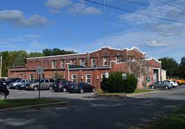
An Amherst & Sunderland Street Railway Company car passes Amherst Center and Town Hall in 1903, three years prior to the company's lease and subsequent acquisition by the Holyoke Street Railway. Photo: Wikimedia Commons / Public Domain
Amherst History Month by Month
Editors’ note: The Indy is committed to making corrections whenever needed in order to continue to apply the highest possible standards of accuracy to every article. Usually when errors are brought to our attention, we correct the article itself expeditiously and with little or no fanfare. However, following the receipt of several suggestions for corrections from our readers for this article, the author has opted to revise the article and we repost the revision here under a new title. We have left the comments on the original article intact, even though in some cases, they may no longer apply to the revision. We believe that the conversation that this article has stimulated is interesting and civically healthy. We note that some of the claims in the comments are disputed in other comments. Please note that we cannot fact check all letters/comments to the Indy, and also rely on the combined wisdom of readers. This can make for a vibrant page, but occasionally, it becomes apparent that a letter or a comment is unpublishable. We continue to welcome corrections (amherstindy@gmail.com). Our comment policy can be found here.
A while after I’d moved to Amherst, I learned that our Department of Public Works (DPW) building not far from the Mill River and Groff Park began its life as a trolley barn, a key element in our town’s historic trolley system.
Aside from the railroads, our trolleys were the easiest way to get around Amherst historically until the early-to-middle years of the 20th century, when buses and cars largely replaced them.
I grew up remembering the trams in London, with their high-strung cables above me seeming spider-like, even a little threatening at times, to a small child. The tramways were soon superseded by London’s famous double-decker red buses and more and more motor cars. In North America, street railways and streetcars were common in the late 19th and early 20th centuries.
Boston’s street railway of omnibuses was first drawn by horses, with its earliest service operating between Cambridge and Bowdoin Square beginning in 1856. Streetcars were electrified in Boston in 1889. And even now, San Francisco is famous for its cable cars.
Amherst’s trolley system began in the late 1800s, around 1897, when the Cowls and Childs company, which included Walter Cowls, built the Amherst—Sunderland line. Passengers boarded its cars that June, and the route, which operated until the mid- to-late 1920s, ran along North Pleasant Street.

Next to what is now Riverside Park on Montague Road (now a mini-mall with its own post office, pizza place, Cumberland Farms store, Indian marketplace, and more) was a popular trolley station. Three years after it began operations, the line was extended to Northampton. Not long after, in 1907, Holyoke Street Railway bought the line and connected it through the Holyoke Range to South Hadley and the city of Holyoke. The trollies ran there until 1932.
The Mill District today pays homage to the fascinating history of North Amherst, including the trolley line and the often-neglected history of African-American residents there. A new “trolley barn” designed in 2014 by Kuhn Riddle on Cowls Road offers mixed-use residential and commercial spaces, and other parts of the Mill District tout boutique shopping, a general store, local-art based art gallery and workshop space, fine foods and drinks, three playgrounds, and various outdoor recreation-related opportunities. A

The trolley shelter that was once at UMass, technically known as a waiting station shelter, was built when the university was still known as Mass Aggie, the Massachusetts Agriculture College. It was designed in the Craftsman style of the 19th and early 20th century, an American equivalent of the Arts and Crafts style in England at that time. Both emphasize simple, vernacular styles, and the shelter at UMass imitates a rural Japanese style,, perhaps celebrating the important relationship UMass had (and still has) with its sister university, the Imperial College of Agriculture in Sapporo.

It was a picturesque little rectangular pavilion, enclosed by brick piers, designed by Arthur Sharp, a landscape gardening student, before he graduated in 1910. Until the late 1920s, it provided shelter for people waiting for the trolley, and then served people waiting for the bus. For a while, it was the subject of a great preservation “save.” In 1994 (a year after Amherst formed its sister city relationship with the Japanese town of Kanegasaki), it had withstood the tests of time. But in 2012, it was demolished to make way for the new Integrative Learning Center’s academic buildings and the pull-in area for the bus transit system there. A construction company demolished the structure in May of 2012 despite having been ordered by the University to not proceed with a planned demolition.

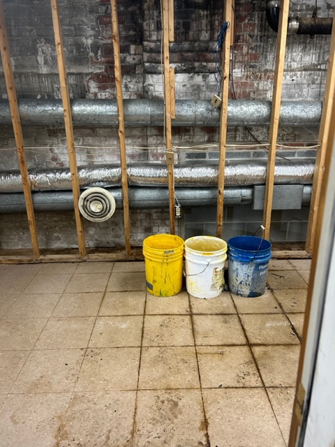
The former trolley barn in South Amherst, now the dilapidated headquarters of the DPW, could be carefully restored. DPW staff there operate out of a very neglected and dangerous building, which is ironic, given that they manage the condition of much of the town’s buildings and infrastructure. The Indy has written about this deplorable issue, most recently noting interior leaks, in photos taken after a rainstorm in 2023.
Updated:
Four things. First, the UMass Trolley Shelter was never moved — it wouldn’t have been possible to move a brick building like that. And it wasn’t supposed to be torn down, it just was in the way of contractors and it was a big mess when they did tear it down. Your special collections picture shows how much North Pleasant Street was been raised over the years because while you can’t really see it from Larry Kelly’s photo, the sidewalk was about six inches higher than the shelter’s floor in the end. Instead of stepping up, one stepped DOWN into it.
Second, the thing to remember about trolley’s a century ago is that most of the streets weren’t paved, and back then paving consisted of hand-laid granite blocks, aka “cobblestones” where a couple hundred yards extension was a major accomplishment and expenditure. Concrete and then asphalt came later, but back then the streets were dirt — or mud. The only all-season transportation was a railroad track, be it the trolley or railroad.
This is why the railroads held such power over rural areas, including Amherst, and why the Interstate Commerce Commission came into being. With the exception of maybe the late fall when the roads were frozen and before the snow fell, anything you wanted to sell or buy had to be transported by rail — and not as much in Amherst (which had two railroads) but trolleys elsewhere did a significant freight business as well.
Third, roads were built to meet the needs of the trolley. That’s an old trolley turnaround in North Amherst (to the west before the intersection) and the “S” curves on the road up into Shutesbury were built to facilitate the trolley. It couldn’t go straight up the hill like a car can, and while the trolley pole in the rear could swing left & right, it could only reach so far. So what they did was run the overhead wire (catenary) straight up the hill and then curve the tracks so that the trolley’s pole could remain in contact with it — the curve reducing the percentage of grade by extending the distance the trolley traveled. And the road followed the tracks.
A few of the curves have been eliminated but most of them are still there. You will see the same thing going up Sugarloaf Mountan and the road (I think it is 114) to Conway. The trolleys built a lot of the roads, and there is still a trolley bridge in South Amherst before you get to the DPW/Trolley Barn.
Fourth, they weren’t using electricity for environmental or economic reasons — the coal-fired steam locomotives of the day belched smoke & soot and were jaw-droppingly inefficient by today’s standards. The Hoosac Tunnel was electrified because there wasn’t enough air in the tunnel for the coal burning trains to make it through at anything more than a crawl, and the New York train tunnels were electrified after several horrific accidents caused by smoke & steam impeding visibility.
The trolleys were electric because, prior to WWII, there weren’t gasoline or Diesel engines powerful enough to move a vehicle of that weight. The iconic Model T had a 176 cubic inch engine but only got 20 horsepower from it. The subsequent Model A, with a 200 cubic inch engine (the size many cars have today) only had a 40 horsepower engine. By contrast, the Diesel DT466 engine (466 cubic inch) that is common in school buses and box trucks today has 300 horsepower, and it’s not uncommon for a trailer truck to have a 600 horsepower engine.
It was only possible to replace trolleys with buses when (a) the roads were all paved (so that the buses didn’t get stuck in the mud) and (b) when engines became powerful enough to have the horsepower that electric traction motors always had, and hence be able to move a heavy vehicle. With Diesel engines it also was a case of reducing the weight/size of the engine — the railroads had developed Diesel engines for locomotives which were then used during WWII in submarines, but they were way too big to fit into a motor vehicle.
Today we think of environmental reasons for using electricity (but where is the electricity coming from?)
But back then, it was all they had (other than actual horses). It wasn’t just that the Model T only had 20 horsepower but it didn’t have gears — it essentially had what chain saws do today, steel bands which grip a spinning flywheel and transfer power that way.
I’m impressed with what people accomplished with what they didn’t have.
Two other things — in addition to likely community opposition to running steam trains through towns (think fire hazard as well as smoke), the rails weren’t heavy enough to support the weight of a locomotive. That’s why they had to use electricity — and often generate it themselves as it wasn’t commercially available at the time.
Street railways were “light rail” — rail is measured in terms of pounds it weighs per yard, with heavier rail having more steel in it and thus being stronger than the lighter rail that doesn’t. While I don’t know the weight of the rails that these street railway used, it was common in the late 19th Century for street railways to use rail that weighed 40 lbs/yard while regular railroads used rail weighing 100 lbs/yard or more.
Second, while Cinda Jones preserved an old barn for Atkins, she built the so-called trolley barn from scratch.
Her family’s sawmill was on that site, and it was struck by lightning and burned — the business never recovered and she decided instead to develop the land. She called it a trolley “junction” although I believe that the actual junction was further south, before the church where some went up to Leverett, some went to Sunderland, and some turned around.
There is NO WAY that any trolley company would build a building like that — they built high one story buildings — high enough so that the overhead trolley wire could be on the ceiling (as it was necessary for the trolleys to move) and maybe with some offices upstairs although usually they would just have windows up there for light and possibly ventilation as they were repairing trolleys in the barn. Using gasoline to clean parts (as was customary at the time), you kinda did want ventilation…
Memory is that there is an old trolley barn being used by one of the DPWs up there, but there wasn’t one in North Amherst and definitely not in the midst of the Cowl’s Lumber complex.
Thanks, Hetty, for the article, and Ed for the detailed comment.
A couple of quick corrections:
1) The DPW building/former trolley barn is near the Fort (not the Mill) River.
2) The Main Street trolley continued east, up Pelham Rd (which become Amherst Rd once it crosses the border into Pelham) and served a “resort” at the foot of Mt. Orient (that’s another story).
3) I am not aware of a trolley into Shutesbury, but if anyone can offer a reference/map….
4) The southbound trolley line runs through the Holyoke Range State park but disappears for a while near the Lane Quarry at the Notch where the widened version of 116 passes: it’s an easy hike and might make a nice rail trail over the Notch someday….
Here’s a good geographic summary of the trolley system that served the Amherst area:
https://en.wikipedia.org/wiki/Holyoke_Street_Railway
And there was more extensive street railway system that included a trolley between Amherst and Northampton which followed the course of present-day Route 9:
https://en.wikipedia.org/wiki/Connecticut_Valley_Street_Railway
with this historical map:
https://en.wikipedia.org/wiki/Connecticut_Valley_Street_Railway#/media/File:Connecticut_Valley_Street_Railway_1910_map.jpg
Light rail (trolley lines) are shown in red, heavy rail (steam, and later diesel-electric) shown in black – the Norwottuck Rail Trail follows black line crossing the red line (now Route 9) between Amherst and Northampton.
P.S. An interesting technological breakthrough is noted in the first article: a new welding method which allowed rail to be joined more smoothly than the traditional system using bolts and plates, responsible for the “clickety-clacks” of the old tracks. Continuous-weded-rail is now standard on all heavy rail system (at least away from switches and grade crossings), though it was only a few years ago that it was installed on the north-south freight line through Amherst.
It’s always possible that the line up into Shutesbury was planned but never built — remember that the Southern New England Railroad in Palmer was graded but never built, in part because the man behind it went down with the Titanic.
The more I think about this, they probably were thinking about going down into the Quabbin, possibly building a hunting or fishing lodge and attracting rich tourists from Boston. Like with the Amherst/Pelham Road, the roadbed continues beyond 202 and down into the Quabbin — I don’t know exactly where or what might have been there.
The state started seriously talking about flooding the valley in 1922, and that might have been the end of this. All I know is that those “S” curves are laid out in a manner such that a trolley could maintain contact with an overhead wire while climbing a hill. And I do wonder how far up into Pelham it went because while a street railway could climb grades that steam trains couldn’t, it wasn’t able to climb steep hills. (The Mount Tom trolley had the cable and the trolley going downhill serving as a counterweight to pull it up the hill.)
Great to have all this additional information from these gentlemen about the trolley system in our area. Apologies for mistaking the Fort and Mill Rivers!! Elemental my dear Watson!
I knew I wouldn’t be able to climb out of the weeds with all the twists and turns of trolley car technology so I am very interested to see some of it shared here.
About the trolley station at UMass…..when I saw the oldest photos of the building I imagined it on the other side of the Hasbrouck Lab building somewhere (wrongly) and then I found a wonderful map from the Mass Agricultural College archives which shows it on North Pleasant Street (its ONLY location) so again, apologies for that error. The archives also contain this postcard https://www.digitalcommonwealth.org/search/commonwealth-oai:fx719r963
Can this article either be heavily fact-checked and edited or taken down? It’s not accurate. Even corrections aren’t accurate. Wikapedia is not a good source for facts. If this stays up as is it will contribute to more misinformation out on the web.
The trolley era was brief couple decades. Not very long the historical way to get around town.
in 1897 tracks went from North Amherst to Amherst
1926 – discontinued Sunderland line
1928 – discontinued North Amherst
1932 – Holyoke line stopped
My great great grandfather, Walter Cowls Jones as a partner in the construction business Cowls & Childs and then Cowls, Childs & Day, built roads, changed grades and undertook various large construction undertakings including developing the Amherst and Sunderland Street Railway System. I have most of the Amherst and Sunderland Street Railway Company records as WD Cowls was a major stockholder and president for 10 years until the company was sold to the Holyoke Street Railway company and then he became president of that successor company . WD Cowls used locally grown and milled timbers for ties and built a massive rock crushing facility on the Notch in Amherst (owned by Lane today) to crush stone for railway beds..
Walter Dickinson Cowls designed and developed the regional Trolley system from his home on the corner of Cowls and Montague roads where all receipts and payroll records of the trolley system remain today. His old Onion Barn (two doors down from where I designed the new Trolley Barn on Cowls Road) was first used to house trolleys for a decade, next to the powerhouse. Both the trolley barn i designed and the onion barn WD Cowls used to store cars (which i call Mill District DEPOT today) are located across the street from where our sawmill that burned and the one we rebuilt existed , currently where The Mill District General Store sits today.
The roll top desk in my office was bought for $32 from Amherst’s Marsh Furniture store for Amherst to Sunderland Street Railway use.
Riverside Park mall was named for the trolley destination – Riverside Park.
A line was devised/ drawn/initiated from Amherst to Northampton but it was never built due to opposition from Amherst/Sunderland/Holyoke Co. I believe Northampton my have connected to Amherst through South Hadley but not on Route 9. The trolley never went to Shutesbury. The S curves were for horses.
Will send photos
Cinda
As a librarian, I need to correct this statement: “Wikapedia [sic] is not a good source for facts.”
Wikipedia is actually a good source for facts, according to research that has compared Wikipedia with Encyclopedia Britannica, the scientific and medical literature, and other sources. The first was a study published in Nature, in 2005, and every study since then has simply replicated and expanded that finding.
You might enjoy the Wikipedia article on the reliability of Wikipedia which cites to a lot of that research; the citations have links to the full-text, so you can verify the citations yourself.
Wikipedia is still a popular punching bag with comedians, but the idea that it’s not a good or valid or reliable reference tool died out years ago.
As to the substance of Cinda Jones’ comment — I can’t speak to how much it was used as the way to get around town, but 1897 to 1926 is basically three decades, which is a pretty substantial amount of time.
Laura Quilter (a librarian)
I have written to Cinda Jones, incorporated some of her comments into the revised version of the column and I hope this rather awkward entry into the world of trolley history will be a “lesson learned.”
Dear librarian – anybody can write anything in Wikipedia. It’s not fact checked. The wiki quotes in comments above about a trolley line going down Route 9 are case in point. The Holyoke St Railway Co stopped that line from being built after it was designed and mapped.
Dear Cinda —
It is true that anybody can write anything, but it is not true that it’s not fact checked — there are hosts of editors who require citations for content, verify citations, etc. All encyclopedias have errors, and the benefit of Wikipedia is that users who spot such errors can flag them (on the talk page or the page itself), and that users can see the process of editing and “fact checking” — a process which is not as crystal-clear as it might seem. For instance, Cinda — you assert that “The Holyoke St Railway Co stopped that line from being built after it was designed and mapped.” Can you provide a publicly available citation to that information? If so, then it can be verified and corrected.
Happy to talk about Wikipedia any time, but I hate to (ahem) derail this conversation.
Good to learn that Cinda Jones has some primary sources about the street railway system in the Amherst area!
The map I shared earlier suggested the Northampton and Amherst Street Railway alignment was on present-day Route 9, yet a question was raised about whether that connection between Amherst and Northampton was ever completed.
Noted local historian Daniel Lombardo [1] writes “In 1895 Amherst had spurned the efforts of the Northampton Street Railway Company to extend its lines to Amherst. Amherst’s businessmen opposed making it easy for Amherst customers to shop in Northampton.” But by June 1897, “AMHERST MADE A LEAP forward into the age of the trolley.” The first tracks of the Amherst and Sunderland ran down North and South Pleasant Streets from North Amherst to the Boston & Maine Railroad Station (present-day site of Amherst Farmers Supply along the Norwottuck Rail Trail), with a spur down Main Street to the Amherst Depot, extended in October 1897 to the East Amherst Common, “but the greatest change came in 1900. After a bitter rivalry between the Amherst and Sunderland Railway, and the Northampton Railway, a link was finally made connecting Amherst and Northampton.”
Because this Northampton and Amherst Street Railway trip (at least initially) “included a crossing of the Connecticut River bridge in large wagons” according to Lombardo, one might still argue “on a technicality” about when (or even whether?!) that connection was completed. (This iron truss bridge served the public from 1877 till it was replaced by the Coolidge Memorial Bridge in 1939; the trolleys were gone
Unfortunately the photo from [2] isn’t clear enough to discern (or exclude) the presence of rails on its deck and overhead trolley wires – maybe Cinda (or another primary source) can share better evidence (one way or the other)?
As for Lombardo’s the closing paragraph (on Amherst business seeking captive customers and complaining about competition): some things just never change…!
[1] https://www.amherst.edu/system/files/media/1484/SoundscapeTalesOfAmherst.pdf
[2] http://archive.northamptonma.gov/weblink/0/edoc/572329/The%20Brith%20of%20a%20Bridge-Hampshire%20Life-5-4-1989.pdf
P.S. Reference [2] does state that both this 1877 truss bridge and a later “trolley bridge belonging to the Northampton Street Railway Company” would be scrapped (for war materiel — indeed: some things just never change) upon completion of the Coolidge Bridge in 1939. It would be nice if someone can locate photos of that trolley bridge in situ….
P.P.S. Just found one! https://credo.library.umass.edu/view/full/murg130-i0007769
P.P.P.S. Bingo!!! https://www.digitalamherst.org/files/original/spc_640a_1cf562582a.jpg
P.P.P.P.S. The caption and metadata for that 3 bridges image: https://www.digitalamherst.org/items/show/46