Amherst History Month-by-Month: Nuttingville
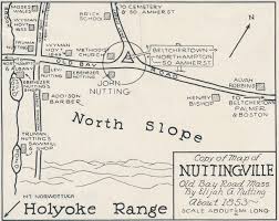
Map of Nuttingville (Amherst) dating to 1853. Photo: Jones Library Historical Collections
This is the first in what is hoped to be a monthly column on historic preservation, taking a look at Amherst’s historic buildings and neighborhoods and the stories behind them. It may also, from time to time, explore the challenges of historic preservation in a town such as ours that is so rich in historic resources.
Imagine a local road where, even in the 18th century, you could drive by meadows and fields, high with corn, and picturesque areas of woodland in the shadow of the Holyoke Range. Here’s a hint: the thoroughfare connects Belchertown to Amherst and Hadley, and is now known as Bay Road. It is actually an ancient indigenous trail that became a popular dirt road in the 1700s on the Boston to Albany route. Along the route, was an important brick house and inn, known as the Albany Tavern and the road ended at the Hockamum Ferry before a bridge was built over the Connecticut River.
Bay Road hides as well as reveals its history. It is not just that it was a well-sited trail on a transportation network for local tribes like the Norwottuck and Nipmuck, but also because, on Hulst Road, you will discover the oldest operating Community Supported Agriculture (CSA) site in western Massachusetts, the beloved fields known as Brookfield Farm. There is a plan in place to make Bay Road a protected corridor via a National Register nomination, the Bay Road Corridor Area, that was submitted in 2018. This pending nomination includes the Nuttingville District. Quite literally ‘ville’ is the French word for town – so this is the ‘town’ of the Nutting families.
Nuttingville is bordered by Mechanic Street and South East Street – or East Street as it used to be known. This semi-rural landscape has roads lined with a mixture of low-density buildings, mostly barns and one- to two-story homes, some with detached garages; there are ranches, split levels, some with lovingly tended gardens or woodland.
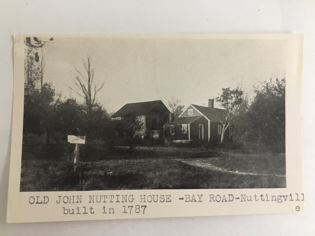
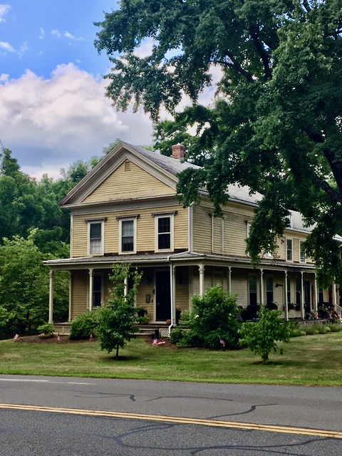
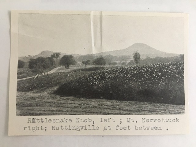
One house, originally the 1787 home of orphan, “little John Nutting” (1762-1834) has changed much over time. One of his sons helped to build the South Amherst Congregational Church. Another distinguished house is a Greek Revival home, once the dwelling of Truman Nutting, that has an attached barn with a lantern. In the 1850s a Methodist church (now demolished) was built a few houses along Bay Road to the east, giving the neighborhood a wider choice of worship services for those who wanted them. Truman Nutting’s property anchors the corner of Bay Road and Mechanic St and Mechanic actually crosses Bay Road and dead ends at the base of Mount Norwottuck. It was here that Nutting’s sawmill and shop was located. Ebenezer Nutting had a shop closer to the main road.
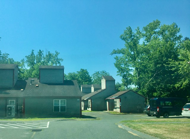
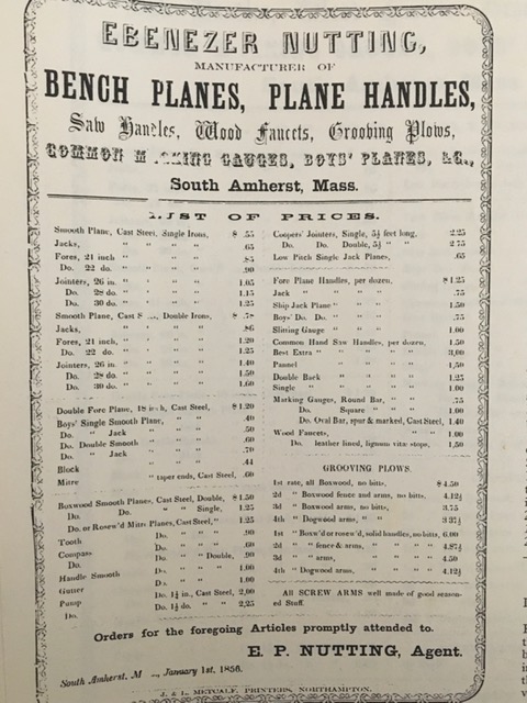
Papers in the Jones Library Special Collections include cuttings from newspapers and historic print media about this interesting local family. There is a beautiful catalogue from Ebenezer’s shop of his bench planes and plane handles. My dad, a sculptor, would have loved this place! And the Nuttings of course live on, much like the native peoples who first traveled through this area. We have a Nutting Avenue in town, near the UMass campus and the AHA John Nutting Apartments, next to Chestnut Court, that is a complex of five contemporary units in three buildings for families who have a member with a mobility impairment. Each apartment is wheelchair accessible, has a roll-in shower and 3 or 4 bedrooms (one of which may be set aside for use by a live-in personal care attendant, if required).
What has changed and what is preserved in a town like Amherst is so much the result of how we interact with the built environment and with what people have left to us. Making it possible to see the town history revealed in its evidence, drawn from many sources (photographs, maps, print media) is always helpful – but the best material cultural resources for holding the memories alive are held in our trails, roads, neighborhoods, buildings and view-sheds of the town itself. The neighborhoods are as important as the downtown and each area helps to reveal what is unique and special about Amherst itself.
Hetty Startup lives and works in Amherst and is a member of the Amherst Historical Commission.
Many thanks to Hetty Startup for this exciting new series of explorations of Amherst’s buildings and neighborhoods. This is not only valuable per se but is particularly needed right now as we enter a new and different phase of both creating and destroying our built environment. It would be wonderful if a parallel series of articles could link our history as a town to our natural and built surroundings. That history, still reflected in our street names, would be revelatory about our complicated past and helpful in confronting our complicated present.
Brava, Hetty!
The John Nutting for whom the apartments are named lived on Pine Street
In North Amherst. He was the son of the beloved and distinguished professor of biology, Bill Nutting.
Thanks, Hetty Startup (hey, is that a nom d’plume?! ;-)!
After giving a short talk last weekend (at the Mass Central Rail Trail Golden Spike 2002 conference in Gilbertville) and suggesting that mid-19th-centrury railroad route, whose western end is now the Norwottuck Rail Trail, is effectively part of an ancient path network connecting the Connecticut Valley with Massachusetts Bay (and using this to argue that completing MassCentralRailTrail is “historically-inevitable” and thus deserves our enthusiastic support), I tried to hunt for more historical (and pre-historic) information to substantiate what little I’ve known over the past 34 yers that I’ve lived here.
Can please share any documentation that would substantiate the hypothesis that Bay Road (running “North of Norwottuck” — a nickname for Amherst, used as the title for a self-published book of the same name, now digitized —
https://archive.org/details/northofnorwottuc00elli/mode/2up
by amateur historian and South Amherst native, Marjorie Atkins Elliott — one finds hints there about early wheeled transportation on page 20, but found little — besides a b&w photo of old prehistoric human remains unearthed more than a century ago near Bay Road in present-day Amherst and Hadley — there about earlier trails) is part of this network?
Aside from anecdotes told by a former Town of Amherst planner (and amateur local historian), there’s a modern sketch (original source unknown to me) of the ancient path network connecting the Connecticut Valley with Massachusetts Bay in the Historical Atlas of Massachusetts, a 1991 “coffee-table” book by two former UMass colleagues (Richard Wilkie and JackTager)
http://www.geo.umass.edu/faculty/wilkie/Wilkie/maps.html
and the particular map (if a picture is worth a 1000 words, then perhaps a
good map is worth > 10000)
http://www.geo.umass.edu/faculty/wilkie/Wilkie/hist_mass_p12.jpg
shows a fork in the east-west trail along the Chicopee River near present day Palmer; the south fork continues along the river, but the north fork appears to skirt the Holyoke Range, though it’s unclear if it depicts (or merely “alludes to”) the route of present-day Bay Road….
A century-old self-published book The Bay Path and Along the Way by Levi Badger Chase (now that’s a nom d’fur-pelt! 😉
https://books.google.com/books/about/The_Bay_Path_and_Along_the_Way.html?id=s91CAAAAIAAJ
attempts to tie things down with early 1600s deed records, but if you have any better sources — with good maps! — I’d be forever grateful,
— Rob (which is my pronoun and my nom d’chalk)
Hello to Rob – My advice is to start with this document by Shannon Walsh, who spoke recently with the Amherst Historical Commission about our town’s Preservation Plan, She developed the nomination form for the Bay Road/Nuttingville National Register District. This was submitted in 2018 but is still pending approval as I mentioned in my article. I’d post the actual document here but not sure how and will ask.
Thank you Hilda for the information about how the Nutting Apartments were named.
One correction – the “Greek Revival home, once the dwelling of Truman Nutting,” has a *detached* barn with a lantern. I would post a photo of this part of the property but not sure how to.
Hetty, so enjoyed this article! It took me back to my copy of ‘W.H. Atkins, ‘Leave the Light Burning, South Amherst 1871-1952’ (1972) edited, as Rob mentions by his daughter, Marjorie Atkins Elliot. A wonderfully informative history of South Amherst where Carpenter and Morehouse’s history (the latter another So. Amherst resident) ended. Look forward to more of your articles!
Thanks for this article! I live in one of the Nuttingville houses, kitty-corner from the Greek revival on the corner of Bay and Mechanic Street extension. I’ve done a little research into my house, but there are so many conflicting dates and accounts! It’s still delightful, though, to imagine what my neighborhood was like when my house was young—in the 1860’s and 70’s. Thanks again!
Thank you so much for this wonderful article, Hetty. I grew up on Bay Road in South Amherst, across from one of the trails leading up Mount Norwottock (and attended the South Congregational Church that Nutting helped build). Moreover, as an undergrad at UMass, I worked as a Researcher/Cartographer for the Historical Atlas of Massachusetts. I distinctly remember finding an old map of the ancient path network in archives at UMass. I wish I could share more, but I don’t remember which archive I found it in — what I do know is that this map is NOT reprinted in the Atlas of Massachusetts.
I also seem to remember coming across information that Bay Road was initially a migratory path for animals.
I am very curious to learn more about the history of South Amherst, so I look forward to more of your posts!
Corrina,
Would you be able to contact the authors (Tager or Wlikie) to help locate it?
By the way, I just performed a play for a math colleague’s retirement in which your namesake mathematician (my advisor’s advisor’s… advisor :-)) had fun shout-out any relation to you too?!
Rob