Mode Shift #3: Supporting Sustainable, Equitable Transportation. It’s Time To Finish Amherst’s Bicycle And Pedestrian Network Map And Plan
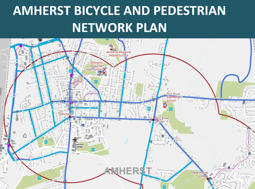
Photo: amherstma.gov
Just over four years ago, Amherst released its first ever draft Bicycle and Pedestrian Network plan. The plan has never been finalized. The piece that was and is lacking is the final network map. This column overviews the development of the draft pedestrian and bicycle plan, its overall recommendations and contributions, the thinking that went into the final revisions of the network map, and how it is that these were never put together into a final plan. It calls for Amherst to finish the pedestrian and bicycle network map and plan, and start using it. It can be used to build a prioritization plan, help the town apply for grants, and set out a plan for designing, funding, and building a complete and robust bike and pedestrian network.
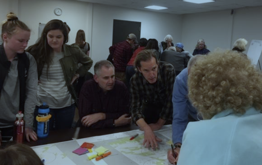
The Amherst Bicycle and Pedestrian Network Plan was drafted with a grant and staff from the Pioneer Valley Planning Commission (PVPC), supported by the Amherst Planning Department. It involved the Amherst Transportation Advisory Committee (TAC), the Amherst Department of Public Works (DPW), , and a robust (and fun!) public meeting in the Bangs Center of some 45 people drawing on maps and writing on whiteboards.
The PVPC began its report by analyzing current biking and walking in the town, and the state of the current bicycle and pedestrian network. Compared to nearby towns, Amherst had significantly more pedestrians, and it had more bicyclists than all neighbors except Northampton.
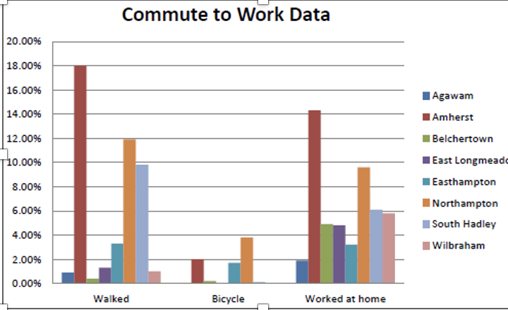
Still, the bicycling numbers in particular were low and showed considerable room for a mode shift. The problem for bicyclists was the high level of traffic stress. Despite “a fairly good network of on- and off-road bike facilities,… traffic speeds, high traffic volume on some roads, as well as bus service and bike/pedestrian volumes (on the UMass campus in particular) make biking unsafe or uncomfortable on many roads throughout the town” (p. 16). The PVPC rated several roads and intersections for their “walkability” and “bikeability” scores. Areas like Cushman and Bay Road were rated only “Somewhat bikable.” The PVPC did not analyze how much this “somewhat” score would be reduced further for a young woman bike-commuting for the first time, an older man on a recumbent bike, a child headed to school, or anyone biking at night or on a rainy day. In the “walkability” scores, distances, lack of sidewalks, and dangerous intersections left many areas rated “car dependent.”
The key questions were how to prioritize and build a bicycle and pedestrian network that could provide connectivity and accessibility—allowing anyone to bike or walk, and to do so in an interconnected trip from neighborhoods to village centers to downtown, or from one mode of transportation (e.g. biking) to another (e.g. walking). Their approach was to (1) identify key routes, and link these to a network map; (2) suggest street, pedestrian and bikeway designs on those key routes and their interconnections; and (3) develop a draft prioritization list. The following summarizes what they came up with.
- Key routes. The Draft Bicycle and Pedestrian Plan identified key routes as: (a) Safe Routes to Schools; (b) connections between village centers “activity nodes” (other village centers, downtown, workplaces, shopping, etc.); and (c) connections to other communities. The connections (b and c) translate to large and medium connector streets like North and East Pleasant, West Street, Belchertown and Northampton Roads, and East Street. Safe Routes to School are designated walking and biking routes within ½ mile of a school building.
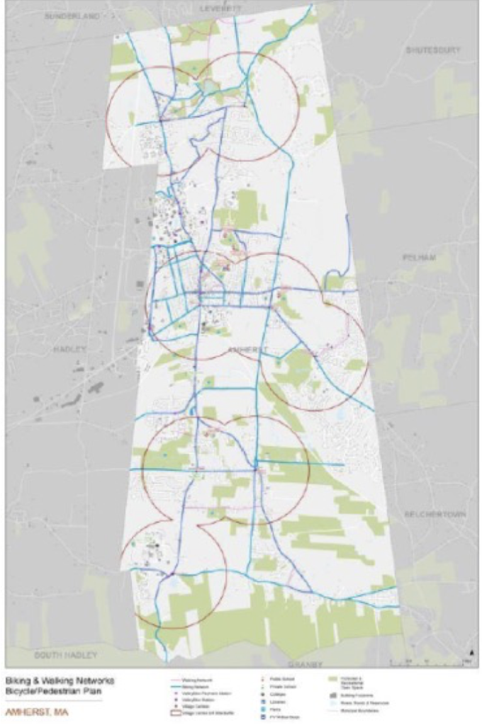
- Network map. The following draft network map was built from the public forum. It identified key bicycle and pedestrian corridors (blue and red, respectively), making sure they connected all the village centers and downtown (surrounded by ¾ mile buffer circles).
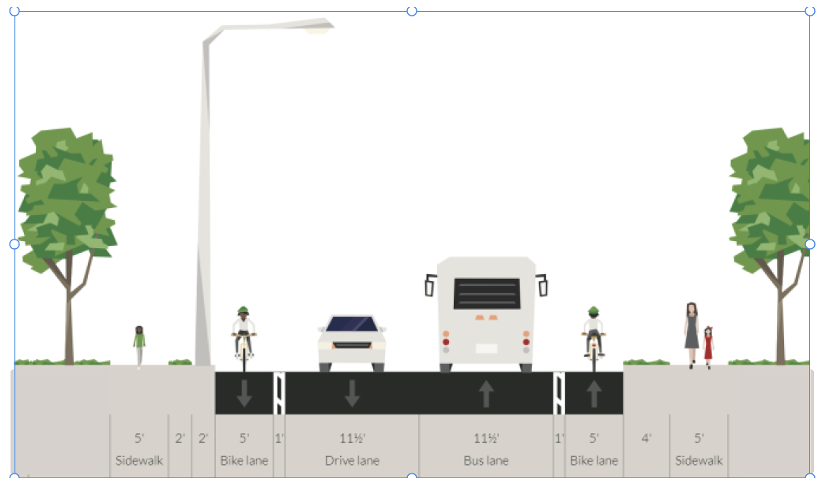
- Street, pedestrian and bikeway designs. An extensive part of the draft plan (pp. 32-55) offered suggested designs for different parts of the Amherst bicycle and pedestrian network. This is an incredibly rich resource. The PVPC offered several different design options for each of five differently categorized kinds of streets in Amherst: the downtown corridor; primary and secondary connectors; external connectors; and neighborhood streets. As just one among many suggested possibilities, they showed an option for primary (larger) connector roads and external connectors of “buffered bike lanes and sidewalks on both sides.” For larger and longer roads, this would significantly increase the sense of safety and buffer for both bicyclists and pedestrians, with relatively low cost or impact to cars.
- Draft prioritization list. The public forum had a strong showing from North Amherst residents. East Pleasant Street and North Pleasant Street emerged as priorities in the draft plan’s draft prioritization list (pp. 60-61). These two streets, one with no sidewalks (north of Olympia Drive) and one with a large number of pedestrian and bicyclist crashes, matched the TAC’s own top priorities. However, many more locations were also listed—Route 116, Mass Ave, Bay Road, South East St, and more. The draft plan’s list provides a template from which a more complete prioritization list could be built. A possible scoring system was also offered. Once adopted, a town prioritization list would allow Amherst to apply for state Complete Street grants for any project on the list.
Despite this excellent work and the resources this plan offered, the plan has never been finished. After the draft was released, the PVPC gathered comments and input, and revised the text. But the Amherst Department of Public Works (DPW) and Amherst Transportation Advisory Committee (TAC) wanted to revise the network map, the core representation of the planned network itself. This made sense, as there was more detailed knowledge of our streets and sidewalks and paths among Amherst transportation professionals and the TAC than among the PVPC.
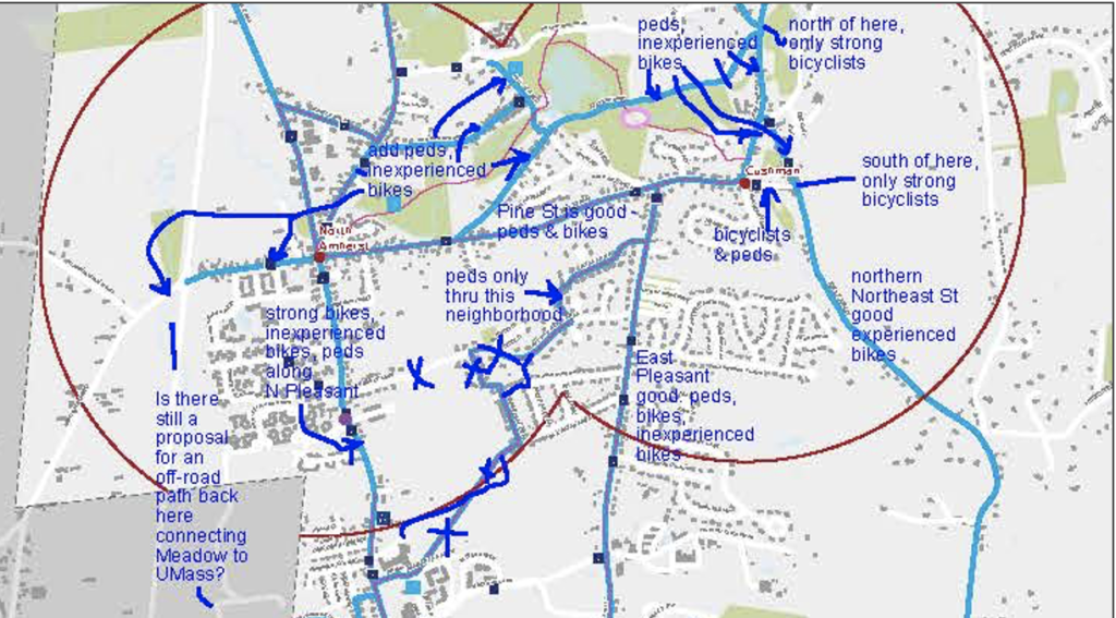
It took awhile, but all the final map revisions were talked through and marked up on pdf and paper maps, completed by the Transportation Advisory Committee (TAC) and the DPW Superintendent in a succession of five meetings on zoom between February 4 and May 6, 2021. The TAC members and DPW Superintendent Guilford Mooring thought carefully about what neighborhoods should have access and where. They also considered where to provide bike and pedestrian facilities for confident, strong, adult bicyclists, and where to also provide for smaller or less confident bicyclists like children or less confident walkers like older adults with walkers, or wheelchair users. In some cases, where bike lanes are on busy roads, they suggested that children, less experienced, and less strong bicyclists would be expected to ride on sidewalks. Future designers might encourage this by widening these sidewalks in order to allow easier passing, marking driveway crossings, adding signs on how to share the path, or making other safety additions.
But these annotations were never converted into GIS (Geographic Information System), output into a map, or combined with the PVPC’s finalized text into a final plan. Some of this delay came because of COVID, and other delays from staffing. In summer 2022 a UMass MS student specializing in GIS offered to complete the map and met with the TAC and the DPW. But the student was not hired nor given the data needed to do the work. There needed to be a competitive hiring process, the TAC was told. Some effort was made to put together a job description, but eventually the summer ended and the student went back to school full time. Since then, the DPW Superintendent has said he prefers an employee, not a student, to do the work. Still the work has not been done.
It is time for Amherst to finish the map, and finish the pedestrian and bicycle network plan. The map and plan are meant to be living documents that can be revised; but first they need to be born.
“Since then, the DPW Superintendent has said he prefers an employee, not a student, to do the work. Still the work has not been done.”
Optimists once hoped the leadership in Amherst would hire someone like Northampton’s Wayne Feiden, while cynics wonder if the cues now come from former New Yorker cartoon editor Bob Mankoff….
This sounds like great work-and close to the finish line! Ir would be great to finalize the plan then start implementation. I appreciate all the hard work that has been down so far.
An HTML error made the Bob Mankoff reference even more obscure than intended: it referred to his book
https://www.goodreads.com/book/show/18112904-how-about-never-is-never-good-for-you
and more specifically, to its title.
Eve Vogel reminded me about this article that she wrote 9 months ago that provided a very helpful update on the status of the Amherst Bicycle and Pedestrian Network plan. I’m commenting on here as it is relevant to a new letter posted today, October 6, 2023.
This week, Amherst had a fantastic Bike/Walk to School event at four of our five schools. I participated in a group bike ride that began at Pine Street in North Amherst and rode the two miles down East Pleasant Street to Wildwood school. The organizer, Kurt Bahneman, thankfully had the foresight to arrange for a police escort, who followed our merry gang of 25 all the way to the school, lights flashing to warn drivers to slow down and give us a wide berth when passing. It was an uplifting and inspiring event that left a few of us parents chatting afterward about how we can effect positive change and get bike and pedestrian infrastructure improvements in Amherst so that biking (and walking) to school can become a regular event without the need for a police escort.
What can be done to finish the Network Plan, finalize the project prioritization list, and get applying for grants and securing other funding so that we can start to realize these improvements?