Sunset–Fearing Townhouse Project Moves Forward
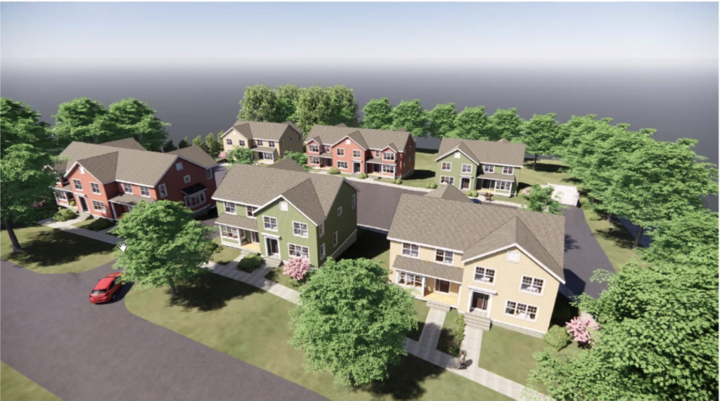
Rendered view of townhouse development at Sunset and Fearing. Photo: amherstma.gov
Report On The Meeting Of The Amherst Planning Board, March 16, 2022
Highlights
- Seventeen-unit townhouse complex proposed for Sunset Avenue and Fearing Street
- New floodplain maps need approval this year
- Downtown zoning recommendations in Rapid Recovery Planned discussed
This meeting was held over Zoom and was recorded. It can be viewed here.
Present: Doug Marshall (Chair), Maria Chao, Jack Jemsek, Thom Long, Janet McGowan, Andrew MacDougall, and Johanna Neumann
Staff: Christine Brestrup (Planning Director); Pam Field-Sadler (Assistant)
Ten members of the public were in attendance.
No general public comment was offered. The minutes from November 3 and March 2 were approved as amended.
Townhouse Development Proposed For Sunset Avenue And Fearing Street
Developer Barry Roberts is planning to erect six townhouses with a total of 17 units ranging from two- to four-bedrooms in two rows on Sunset Avenue at the corner of Fearing Street. The project received a certificate of appropriateness from the Local Historic District Commission and will need a special permit from the Zoning Board of Appeals (ZBA) for final approval. The Planning Board offered comments on the project, but did not hold a public hearing as the public hearing will be before the ZBA.
The project was presented by Attorney Tom Reidy of Bacon, Wilson and architect Jonathan Salvon of Kuhn, Riddle. Two existing houses at 164 and 174 Sunset will need to be relocated to allow the townhouses to be built. Of the six proposed buildings, four will be duplexes and two will be apartment houses with four and five units. There will be three accessible two-bedroom units and two units affordable at 60 to 70% area mean income. Amenities at the site will be parking for 47 cars, walkways, screening vegetation, a community garden, and a natural playscape. The site is on a steep slope, but has no wetlands. It is directly across Fearing Street from the Southwest Towers at UMass.
Rents are projected to be about $2,500 per month for a two-bedroom and $4,300 for a four-bedroom unit. Roberts will serve as manager. The project is aimed at families, and Roberts has spoken to the university about the project serving faculty and administrators of the campus.
Planning Board members spoke favorably of the project, although they had questions about who would be occupying the units, as they are right across the street from large dorms. Reidy said that the four-bedroom units only have two bathrooms and are more geared to families than undergraduates, but rental would be available to any responsible tenants.
Johanna Neumann wondered about sustainability features. Salvon said the roof orientation is not optimal for solar, but solar may still be an option due to the efficiency of newer solar units. He said that canopy solar for the parking lot is too expensive. The units will have electric heating with mini splits, but hot water may need to be gas. The parking lot will have the infrastructure for EV charging, though Roberts said he has rarely seen the EV charger being used at his 70 University Drive complex and doesn’t plan to install one at this complex immediately. Salvon said that the community garden could be a site for solar panels if the site is not used for a garden.
Maria Chao said the development seemed rather “car-centric” and wondered about how people would move through the site. She suggested creating more green space and sidewalks with fewer parking spaces. Doug Marshall and Neumann agreed that fewer parking spaces would probably suffice.
In public comment, Dorothy Pam spoke for maintaining the large maple tree on the corner of Sunset and Fearing that is “quite a presence” in the neighborhood and provides a demarcation between the university and the neighborhood.
The project will next go before the ZBA to be reviewed for a special permit. Chris Brestrup, Planning Director, and Pam Field-Sadler, Assistant, will compile the comments from Planning Board members to send to the ZBA. Additional comments should be forwarded to Maureen Pollock, the liaison from the Planning Department to the ZBA.
Updated Floodplain Maps And Bylaws Presented
Amherst participates in the national flood insurance program, which requires accurate maps of the areas of town in the 100-year flood plain zone. The flood maps currently in use were created in the 1980s. Town meeting allocated money to create new maps, which the Planning Department has been working on since 2012. AECOM Engineering was hired as a consultant. In 2017, new methodology using regression analysis for mapping flood plains was developed, so more money was appropriated to create the most accurate maps. These were posted on the town website and affected property owners were notified in 2019. Only one appeal of the designation was received over the past three years.
The new floodplain maps were introduced to the Town Council at the February 28 meeting and will be presented again on April 4 for a vote to refer the maps and the associated Flood Plain Bylaw to the Planning Board for a public hearing. Planner Nate Malloy said that much of the language in the bylaw is standard and is required by the state. The bylaw will be added to the Zoning Bylaw as Article 16, not integrated into existing bylaws.
The town expects a letter of final determination from FEMA by late April, and that will begin a review period of up to six months, during which the maps and bylaw must be accepted by the town and submitted to FEMA. This process will continue to allow landowners in a flood plain to purchase flood insurance through FEMA and may mean lenders will require borrowers to purchase it. The maps can also guide development. For instance, Hadley prohibits new single-family homes from being built in a floodplain.
The FEMA floodplain maps do not affect the parallel Flood Prone Conservancy District, and will not require any additional permitting. The town will need to appoint a floodplain administrator, probably a member of the Planning Department.
The public hearing on the maps must occur within 90 days of the referral to the Planning Board. The new floodplain maps can be viewed here.
Planning Board Comments On Zoning Changes In BID’s “Rapid Recovery Plan”
At the March 2 Planning Board meeting, Brestrup introduced a 151-page Rapid Recovery Plan completed for the Business Improvement District (BID) under a state grant and completed last October. The plan is supposed to offer advice about how the downtown might emerge from the pandemic downturn. The Planning Board expressed an interest in discussing some of the downtown zoning changes recommended by Dodson-Flinker in the appendix to the report. BID Executive Director Gabrielle Gould was in attendance.
Downtown Amherst’s problems, according to the BID are:
- The ground floor commercial requirement for mixed-use buildings, which, it says, has resulted in unfinished and unoccupied space due to the limited market for commercial tenants.
- The challenges of obtaining a special permit, especially related to uses that include live music and entertainment. In particular, Gabrielle [Gould] is concerned about permitting for a proposed entertainment venue.
- The lack of specificity in the Design Review Handbook for the Design Review Board. Applicants are unable to determine what the Design Review Board wants prior to applying to the Board. This results in extra time and money to make revisions to accommodate the Board’s opinions.
- Barriers to building a parking garage on the Pleasant Street Parking LOT, specifically the lot coverage requirement.
- The cap on the number of units allowed in an apartment building (24 units).
- A variety of limitations in the B-L district as compared to the B-G district.
Brestrup noted that since the report was created last October, several of these points have been dealt with or are being worked on presently. The mixed-use building bylaw was rewritten so that only 30% of the ground floor space equivalent is required to be nonresidential. The parcel on North Prospect Street has been rezoned for a potential parking garage, and several of the temporary zoning provisions passed during the pandemic to allow increased outdoor dining and outdoor entertainment venues will most likely be made permanent. Also, the Design Review Board Handbook is currently being reworked. There have been minor changes to the apartment bylaw, and some suggestions for revising the rules for the limited business district have been voiced.
Gould said she hoped to see all of the initiatives in the report come to fruition. She noted that downtown businesses lost 80% of their business when UMass students were not in town during the pandemic in 2020. She emphasized that undergraduates are extremely important to the economic health of Amherst.
Brestrup said that the Planning Department is working on a request for proposals for a consultant for downtown design standards and is looking for funds for a structural engineering study of the Boltwood garage to see if it can support another one or two stories. The department will probably not have time to revise regulations for apartments and the limited business (BL) area this year. Marshall suggested that the Planning Board might want to consider reviving the zoning subcommittee.
The meeting adjourned at 9:50 p.m.
The Rapid Recovery Plan was developed by consulting the BID, the Chamber, developers, and businesses. Their biases are evident in the initiatives cited. The vacant ground floor spaces in the new buildings downtown are attributed to lack of a market for commercial tenants, not to the high rents charged in those buildings. The need for a downtown parking garage is taken as a given, with no data to support it. Gabrielle Gould also stated that businesses downtown are dependent on undergraduates, since business suffered an 80% decrease in commerce when college students were not in town during the pandemic, but she failed to note that all people were urged to limit contact with others until vaccinations were available, so discretionary spending was down for all people. This situation should not be used as evidence that we need to cater mainly to undergrads.
It’s a miracle to see that the Andrews-Laverdiere site off Meadow Street, and the shops at Riverside near the North Amherst Post Office, have become flood-proof on the proposed flood-plain maps. A real miracle….
And when “parking for 47 cars” is included among “Amenities” – heaven help us!
Will the developer also install a PV canopy over the paradisiacal parking lot? 🙂
I am responding to Rob Kusner’s assertion that the Andrews-Laverdiere site off Meadow Street is not in the new flood plain. This site is in the flood plain. Rob may be reading the farm to the south of the Andrews-Laverdiere property as part of the A-L property, but it is separate. The blue area on the maps covers most of the Andrews-Laverdiere property. See map 170 at link below.
https://www.amherstma.gov/DocumentCenter/View/41336/Map_170?bidId=
Thanks, Chris, for the correction. This was the page that suggested otherwise:
https://www.amherstma.gov/DocumentCenter/View/48317/Flood-Zone-Comparisons_2019
The legend on that map suggests this orange area (and the other-mentioned orange area ) were “Removed” from the flood plain by 2019. Are you saying the large orange area at the NW edge of the A-L property is actually still considered to be in the flood plain?
*********************
Comparing both those maps, I stand by my initial comment:
On the map to which Chris refers, one sees two large brown-areas on the A-L property — one just north of J&J Farm, the other at the northwest edge of the A-L property right along Meadow St — that are denoted
0.2% Annual Chance Flood Hazard, Areas of 1% annual chance
flood with average depth less than one foot or with drainage
areas of less than one square mile
according to the map legend.
And on the map to which I referred earlier, showing the 1983-2019 changes, one sees the same two large orange-areas that are denoted “Removed” (again, according to the map legend).
If you could please clarify further, Chris, readers of The Indy — this reader included! — would be most grateful.